|
How Do I Look? |
|
|
Table of Contents
|
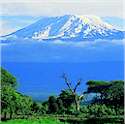
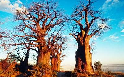
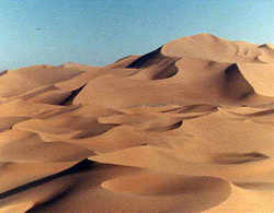
Physical Geography of Africa Objectives: 1. Identify the major geographic characteristics of Africa. 2. Demonstrate their understanding of the physical landscape of Africa by using a variety of materials to create a physical map of Africa. 3. Create a travel brochure of Africa. Key Words: rainforest tropical savannah steppe Mediterranean desert mountain forest topography climate zones vegetation Timeline: 3-5 hours Materials: Microsoft Publisher or Word (brochure template), On-line Resources, color pencils, blank physical map. Procedures: 1. Using a large physical map of the Africa show the students the six different vegetation zones of Africa. Provide students with background information on the six vegetation zones. Explain to students that physical maps illustrate landform regions, vegetation patterns, and climatic zones. Inform students that because of its location and size, the unique African continent has a variety landforms, a wide range of vegetation patterns, and most of the climatic zones. Ask students to describe the physical landscape of Africa. What is the topography like? What climatic zones cover Africa? How would you describe the vegetation of Africa? Record students' responses on the chalkboard so they can be referred to. Tell students that they will create a physical map of Africa. 2. Hand each student a blank physical map of Africa. 3. Using the web links below, have the students research the six different regions. Have the students color in the areas on their blank map which are predominately: rainforest (dark green), savannas (light green), deserts (yellow), steppe (brown), Mediterranean (blue), and mountain forest (purple). 4. Have the students label the following physical features; Atlantic Ocean, Mediterranean Sea, Red Sea, Indian Ocean, Congo River, Cape of Good Hope, Kalahari Desert, Atlas Mountains, Sahara Desert, Nile River, Lake Victoria, Congo Basin. 5. Once students have completed their physical maps of Africa inform them that they will now create a travel brochure to one of the six regions. Visit a local travel agent and request copies of brochures to Africa to share with students. 6. Their brochure should including the following information: landmark/major physical features, climate, people, wildlife, points of interest and clipart/pictures that reflect their selected region. 7. Students may use the web links listed below or conduct a search using Google, Yahooligans, AltaVista. Assessment: Physical map of Africa and African brochure Extension Activities: Have the students create a relief map of Africa, using indigenous dry foods of Africa. Have the students prepare a virtual trip to an African region. Web Links: Mount Kilimanjaro: On-line journey through the land of Africa. Includes general resource information and clips. The Land: Online expedition to significant geographic regions of Africa. Climate of Africa: General resource site for weather in Africa. Africa Geographia: explore on-line several geographic regions of Africa such as Botswana and Ghana. Africa's Geography: Detail research site on the physical landscape of Africa. World Book: General reference encyclopedia on African studies. |