 Subject: Social Studies, Literacy, Art Subject: Social Studies, Literacy, Art
Grade Level: First Grade
Materials: Laptop computers (enough for all the students to work in partnerships) clipboards, pencils, a smartboard, and access to parks and playgrounds of various varieties and sizes.
About: In this project, students visit a variety of parks and playgrounds in Brooklyn. They bring clipboards and sketch various things they see. After each visit, they compare and contrast the differences between a park and a playground, and create class definitions of each. A smartboard is employed to see what parks look like from an aerial view, and students see the impact these parks have on our urban landscape. After much discussion, the children pair up to plan their dream park by using the Gotham Gazette park planning game.
This park study is part of a larger unit on neighborhoods. Eventually, the students build a neighborhood out of shoe boxes and, in addition to many other important places in the neighborhood, two students will be responsible for building the park.
The highlight of this unit is the acquisition of extensive knowledge about urban parks. Students visit three very different parks, which lends itself to discussions about how one defines a park. By the time they are ready to plan a park, on paper and on the Gotham Gazette website, students are able to do so with much confidence. In addiiton, all of the learning is extremely interactive, which benefits a variety of learning styles. Students walk, sketch, have discussions, and utilize technology in order to highlight how parks are planned and how vast amounts of land have been set aside by previous generations for future enjoyment.
This study is particulary important for urban students--and teachers! Parks play an important role in students' lives, as they they don't have expansive backyards and endless woods. It is also great because it is interactive and hands-on. The students can visualize everything that is being discussed because they have been there and examined all the parks. It is best when you have a variety of locations in close proximity to your school.
| The students will develop a better understanding of how a park benefits a community, specifically an urban community. |
| The students will think critically about what is (and is not) included in a park. |
| The students will differentiate between a park and a playground. |
| The students will develop a better understanding of mapping, and how it helps us to see our world from a different perspective. |
| The students will work cooperatively in small groups to plan a park. |
| The students will recognize that parks can vary considerably, based on the location, the amount of space allotted, and how it is used. |
|
|
|
|
| The students read, write, listen, and speak for information and understanding. |
| Grade: K-5 |
| Subject: ELA |
| The students read, write, listen, and speak for critical analysis and evaluation. |
| Grade: K-5 |
| Subject: ELA |
| The students read, write, listen, and speak for social interaction. |
| Grade: K-5 |
| Subject: ELA |
| The students draw maps and diagrams that serve as representations of places, physical features, and objects. |
| Grade: K-5 |
| Subject: Social Studies |
| The students locate places within the local community, state, and nation. |
| Grade: K-5 |
| Subject: Social Studies |
| The students investigate how people depend on and modify the environment. |
| Grade: K-5 |
| Subject: Social Studies |
| The students identify and compare the physical characteristics of different regions and people. |
| Grade: K-5 |
| Subject: Social Studies |
|
| Grade: |
| Subject: |
|
| Day 1: A Visit to the Brooklyn Promenade and Carroll Street Park |
| The students will familiarize themselves with things they see in a park. |
| The students will have a better understanding of the diversity within parks. Parks can be surrounded by a variety of landscapes, they can be near water, can be exclusively a playground with benches and a fence, or be inclusive of adults and children. |
| The students will recognize that within walking distance of their school, there are two parks that are extremely different from each another. |
| The students will begin to think about the definitions of a park versus a playground. |
|
|
| Clipboards, comfortable shoes |
| 2 sunny days (not necessarily consecutive) |
|
|
|
| We visit the Brooklyn Promenade, a famous park in Brooklyn Heights that overlooks the Manhattan skyline and the Brooklyn and Manhattan Bridges. We discuss the neighborhoods we pass along the way. Within a 15-minute walk, we pass through three! |
| We sit on the benches that overlook the Manhattan skyline, and talk about what we notice. |
| I pass out paper and pencils and, using clipboards, the students begin sketching the skyline. I walk around and help those students who are having a hard time. I remind the students that a skyline is not just a picture of two buildings up close. It is the whole length of the river...it is everything they see. At this age level, this is a difficult concept for some children. |
| The students finish their sketches and, afterwards, we pass by the dog run and talk about why is important for city dogs and city dog owners. During our walk home, we talk more about the neighborhoods we pass through: Boerum Hill, Cobble Hill, Brooklyn Heights, and DUMBO. Upon our return to school, we have a discussion about the Promenade and how it benefits the community. |
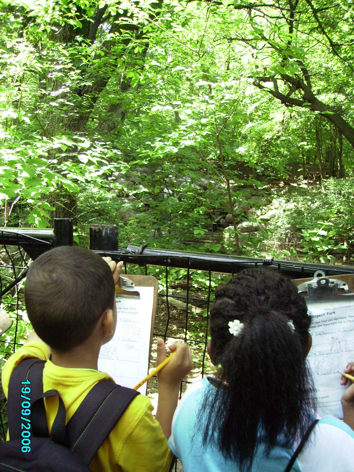
| Two days later, we take a trip to Carroll Street Park. Once again, we bring our clipboards. Refer to the corresponding picture, on the right side of the page, of the Brooklyn Promenade and Carroll Street Park.JPG |
| When we arrive, the students sit on the bench and we discuss all the things we see. The students are given a worksheet with six boxes, and draw and label one thing they see in the park in each box. |
| At the bottom of the worksheet, there is a question: "Is this a park, a playground, or both?" I instruct the children to leave that blank until we discuss this further at school. Upon our return, I start a chart that reads: "A playground is..." As a whole group, the students brainstorm a list of things that they would see in a playground. |
| We come up with a class definition for a playground and write it on our chart. Then, we look in the dictionary to see how our definition compares with Webster's. |
| After much discussion about whether this park was actually a playground or a park, the students return to their worksheets and check off their answer. |
|
|
| Draw a picture of something you saw at the Carroll Street Playground or the Brooklyn Promenade. Write about why it benefits the community. |
|
| The students are assessed based on class discussions and the worksheet they complete at either park. Their homework will indicate whether or not they understand the concepts covered in class and on the field trip. |
|
| Day 2: Prospect Park From Above! |
| The students will develop more experience with reading maps and identifying specific locations on a map. |
| The students will compare and contrast an urban landscape with a suburban landscape. |
| The students will recognize online mapping sites as a tool from which they can learn valuable information about where they live. |
| The students will recognize Prospect Park on the map and identify different areas of the park. |
|
|
| You will need a smartboard. Please see the corresponding picture on the right hand column under "Important documents for this lesson plan": 'Prospect Park From Above.JPG |
|
|
|
|
| After logging onto the Yahoo maps website on the smartboard, I type in our school address. The students are excited to see their school on the map. |
| We talk about the different roads we see in our neighborhood. Prior to this lesson, we discussed residential and commercial streets, so the students have an understanding of this concept. One of the things that came up in the discussion was that a commercial street was wider than a residential street. This was evident on the map, so I ask a few students to come up and point out streets that looked like commercial streets. I ask them how they knew this was commercial, and they explain their reasoning. |
| We eventually move the map and end up at the Brooklyn Promenade. Once again, it is interesting for them to see a place they have visited. |
| I write in another address (my parent's home address in suburban New Jersey) and, immediately, the screen goes almost completely green. I ask them what they notice. What changed? The students say that there is much more green space on the map. Another student notices how many pools are in backyards. Most are amazed at how clearly you can see the backyards, and how large those yards are. When we return to the urban landscape, I ask what else they notice. Some of their comments are that the yards were much less visible, with no pools. The streets are also wider. |
| Eventually, we move over to the Park Slope area, and I start moving towards Prospect Park. When I reach it on the map, many of the students recognize it immediately. We are able to make out the baseball diamonds and the big pond. |
| This is a perfect opportunity to compare and contrast the greenness of the suburbs with the greenness of Prospect Park. How are they the same, and how are they different? A few students understand that in the suburbs, the greenery is private--it is owned by someone, whereas Prospect Park is a public place for all to enjoy. |
| The best part about this mapping lesson is that it highlights the enormity of the park. On the map, the greenery seems endless, but when we move far enough in any direction on the map, we came right back to concrete landscapes. This is a reminder that Prospect Park is a huge park in the middle of a city, but when you're there, you forget that you are in a city. |
|
|
|
|
| The students draw a map of their neighborhood, making sure they include a park. They also need to differentiate between commercial and residential streets in their neighborhood. |
|
| The students demonstrate their understanding of the topic through class discussion and their own mapping, both in the classroom and at home. |
|
| The students will develop a better understanding of what a park is. |
| The students will deferentiate between a park and a playground. |
| The students will see how proper city planning enables city dwellers to enjoy a park with massive amounts of open space (of course, the word "massive" is relative). |
|
|
|
| Clipboards and pencils |
| Good walking shoes |
| Chart Paper for a Venn Diagram |
| Worksheet with 10 boxes (please see the attached document entitled, park sketches.doc) |
|
| The students begin their walk through the park. We stop to talk about what we see. We are near the playground and the bandshell, so most students bring up those two things. I talk with them about how the playground is only part of the park, and the bandshell is another. I explain that today, we are going to explore all different things in the park, so we can see what the park has to offer. |
| We stop to sketch the playground in one of the boxes. After this, we move onto the bandshell. Then, we sketch picnic tables and grills, and talk about why these things are an important part of the park, and how they benefit the community. |
| We walk on, and discuss the road that loops around the park. It has a bike lane, a walking/running lane, a car lane (only open to cars at certain times of the day), and a dirt path where people can ride horses. The students sketch the lane and we discuss how the road is great for both children and adults. |
| We continue on and sketch a dog beach (an area where dogs can swim), a waterfall, and a turtle basking in the sun on a rock in a wildlife preserve area. |
| As we walk and sketch, the children are amazed at the diversity within the park. Seeing the turtle was a fluke, but it was great, because many of the children had never seen anything like that before. It also lent itself to a brief lecture on cold-blooded animals and their need for basking in the sun. |
| Upon our return to school, we create a class chart with a Venn Diagram. On one side of the Venn Diagram is the word "park" and on the other side is the word "playground." |
| I ask the students to think about what they might find in a park that would not be in a playground. They list many things, such as a waterfall, a bandshell, a bike lane, grassy areas, turtles, dog beach, baseball fields, and more. |
| I ask them to think about what we might find in a playground that would not be in a park. That is difficult, since most parks do have a playground in it. |
| Finally, we move onto what both places have in common. The students mention park rangers, jungle gyms, picnic tables, fences, and garbage pails. |
| We end the lesson by defining the word "park" and write it on a chart as our class definition, and compare our definition to the dictionary's definition. |
|
| For homework, the students write about their favorite thing about Prospect Park. |
|
| I assess performance based on conversation, both during the trip and after, and their homework assignment. |
|
| Day 4: The Features of a Park |
| The students will develop a better sense of all the amenitiies and resources the parks they have visited offer our community. |
| The students will work cooperatively with their partner to fill out the graph accurately. |
| The students will recognize each feature as something that has been planned and developed. |
| The students will be able to better organize their ideas as they prepare to plan our own parks. |
|
|
| A chart that identifies each park and amenities that they may or may not offer (refer to the attached document entitled park checklist.doc). |
| Pencils or pens |
|
|
|
| I begin by asking the students the names of the three parks we visited. |
| After identifying the parks, I ask them what the most interesting feature of the Brooklyn Promenade was. What made it stand out from other parks? Someone answers that the skyline set it apart. When I ask the same question about Prospect Park, someone says it was so big and with so much grass. Another student says that there was so much to do...and it had a waterfall. |
| I introduce the worksheet. The students have to answer a question about each park, such as: Are dogs allowed? Is there grass? What are some things to do in the park? |
| I have the chart written on a big piece of chart paper so I can model how to read the question, talk about it with a partner, and then answer it. |
| I ask a student to come to the front of the class and be my partner. I read a question and we model how to begin our discussion. "Is there grass? Hmmm...we know there was lot of grass in Prospect Park, so we can write "yes" in that blank. But was there grass at the Brooklyn Promenade? |
| I break the students up into partnerships, and they work together to fill out the worksheet. |
| As they work, I walk around and listen to their conversations. |
| After the lesson, we come back to the rug area and use the children's work to finish filling out the graph that I had written out on chart paper. |
|
|
|
| The students think about another park they didn't visit in school. For homework, they sketch the park and label some of the special features. Does it have a place for dogs, a picnic area, grass, etc? |
|
| The students are assessed based our class conversation, their work in partnerships, and the ability to successfully complete the in-class worksheet. |
|
| Day 5: Creating your Dream Park |
| The students will use all of the information they have learned by visiting different parks to create their own dream park. |
| The students will work in cooperative groups and negotiate their ideas for the park. |
| The students will develop their understanding of reading and creating a map. |
| The students will have more experience using the Internet, by navigating the Gotham Gazette website and planning their park. |
|
|
| Prior to this lesson, the students met in small groups (groups of 3-4 is ideal) to discuss their plans for their dream park. They sketched their ideas on a piece of paper, and recreated their sketch on a larger sheet of poster board. So, by the time they are ready to plan their park online, they have already developed a strong sense of what they will include in their park. |
| The language and concepts on www.gothamgazette.com/parksgame/ are very mature for young children. So, I walk them through the plan step by step by moving along with them on the smartboard while they work on laptops with their partners. |
| We begin at the first question, and I read each part, step by step. I give them a few minutes after each question to discuss these topics with their partners. As they talk, I circulate and help them understand any confusing concepts. |
| We move through the whole game. |
| When they are finished, they print out their parks. They can also name their parks. |
| Afterwards, they meet with another group and compare and contrast their parks. |
| Finally, we come together as a large group, and each group presents their parks to the whole class. We notice things that every group included in their plan, or that nobody included. We talk about why they felt this feature was so important, or why they excluded that feature. |
|
|
|
|
| The students bring their park home to show their family. Then, they write about the most important feature of their parks. Why is this feature so important? |
|
| The students are assessed on their ability to negotiate the planning of their park with their partner. They are also assessed on their ability to follow directions as they create their online park. Lastly, they are assessed on how they discuss their park with another group, as well as their class presentation. |
|
|
Jamie Fidler
jamiefidler@hotmail.com
PS 261
314 Pacific Street
Brooklyn, NY 11201
Jamie Fidler has worked in the New York City public schools for 4 years. She currently teaches first grade at PS 261 in Boerum Hill, Brooklyn, and has also taught second grade and pre-school. Jamie received both her Bachelor's Degree in Children's Literature and her Master's Degree in Early Childhood Education from the University of Massachusetts at Amherst. She is a MetLife Fellow with Teachers Network, and is conducting action research on developing comprehension skills with students who are not yet reading independently.
Important documents for this lesson plan.
|