Unit: Making Science/Literature Connections: El Guero
Title: Using technology to research and track the migration route of the gray whale.
Aims:
1. To instill in students an
appreciation for science and a respect for all living creatures and
natural environments.
2. To increase student's competencies
in using computer technology to research information and analyze maps.
3. To employ Internet sites
to create a map.
4. To transfer maps from web
sites to original works.
5. To ensure student's will
respect each other while working cooperatively in small group situations.
6. To enable the students to
appreciate the connection between multicultural literature and science.
Materials:
Novel- El Guero- by Elizabeth
Borton de Trevino, Sunburst Books, 1989
Internet
Apple Works
KidPix
Motivation:
1. Relate to children's knowledge
gained from introductory lesson on the novel El Guero and previous lessons
about the gray whale.
2. Ask questions like:
a. In
the novel, where did Guero and Captain Forker sight the whales? (They were
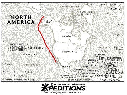
traveling along the western coast of Mexico from Acapulco to San Diego).
b. What was
Captain Forker's explanation of why the whales were there? (The whales
were there because they came down from the cold, northern waters to have
their little ones in warm, safe water).
c. Where
do you think the whales came from? (the whales came from the north, Alaska).
d. Why
do you think the gray whales migrate from one location to another? (Responses
may include: to get warm, to find a new home, and to give birth to their
young).
3. Direct students to online
graphics of whale migration. Good web sites containing migration
routes of the gray whale are:
|
|
http://athena.ivv.nasa.gov/curric/oceans/whales/index.html
http://acsonline.org/factpack/graywhl.htm
http://198.188.248.11/whale/whale2.html
Procedure:
1. Have students find solutions
to the following questions:
a. Where
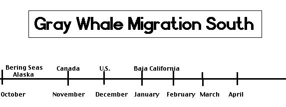
do gray whales spend the winter and the summer? (Gray whales spend their
winters off the coast of northern Mexico and their summers in the
northern Bering Sea).
b. List
and
explain reasons why the gray whales spend the winters and summers where
they do. (The gray whales head south in the winter to have their calves
and to seek shelter in the warm lagoons of Baja California, Mexico.
They build up a thick layer of blubber to keep warm in the colder northern
waters).
c. Find
a map depicting the migration path of the gray whale.
d. Create
your own migration map.
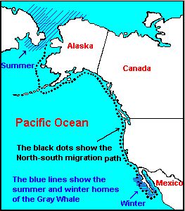
The above map can be found at: http://slocs.k12.ca.us/whale/whale3a.html |
2. Direct students to work in
cooperative groups, as described in lesson
2, to research questions.
3. Have students use the Internet,
online encyclopedias, or computer encyclopedia to research the migration
of the gray whale.
The following are online encyclopedias:
http://encarta.msn.com/find/Concise.asp?z=1&pg=2&ti=761579741
http://encyclopedia.com/articles/13799.html
The following links provide migration maps and routes
of the gray whale:
http://athena.ivv.nasa.gov/curric/oceans/whales/index.html
http://acsonline.org/factpack/graywhl.htm
The following link provides 600 National Geographic maps:
http://nationalgeographic.com/xpeditions
4. Encourage students to answer
each question.
5. Have students work in cooperative
groups transferring gathered research to informative reports.
6. Direct students to transfer
migration maps from web site to informative
reports.
7. Direct students to create
own migration map using internet site and Apple Works.
8. Have reporters from each
group read report and share migration maps.
Evaluation:
1. Students will be evaluated
on the oral reports read and explained by reporters. The reports should
include facts, a map, and diagrams.
2. Check findings from teacher
made tests.
Follow-Up:
1. Transcribe migration patterns
onto a wall map.
2. Have students name countries
and cities along the route. (Alaska, Canada, United States, Mexico)
3. Make a time-line related
to the migration map.
 |