The Continent of Australia

Component: Geographical Understanding
Competency: Recognize that maps and globes are utilized to provide directions as well as other types of information.
Objective: Students use the Internet to locate the various states in Australia and major bodies of water.
Materials: Internet, political map of Australia, cardboard, salt and flour, various watercolor paints, brushes, rulers, pencils, thin makers and world map
Procedures: This lesson will take approximately three days
Day One
1-Teacher introduces the continent of Australia by looking at its location on a world map.
2-Conduct discussion about its location.
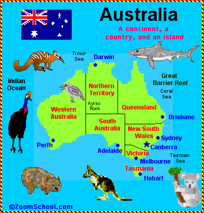
Compare its location with other continents, countries, and oceans.3-Teacher provides each child with a blank map of Australia. Access blank map at Geography.com
4-Students then in pairs go online and use the information online to fill in the different states, territories, and capitals. Zoom School
· Click on Australia
· Use the map online to fill in the information on the blank map teacher provided students.
5-Once students have completed their map. They cut the outline of the map and begin to trace that onto a cardboard paper.
Day Two
6-Teacher prepares salt and flour mixture. Students add the mixture onto the inside of the map to make it a topographical map.
They can create mountains by pinching this mixture. It is important that once the students complete this step the teacher adds hair spray in order to keep insects away.
Recipe for Salt and Flour Mixture:
1. Use a cup of flour and half a cup of salt.
2. Add enough water to make the mixture gooey.
3. If the mixture is to liquid it won't work.
4. It is important to mix well the salt, flour and water.Day Three
7-Students use rulers to make the divisions of the various states.
9-Using a different color for each state student's paint carefully making sure they do not use the same color on two different states. Remind students that the blue should be used only for the water. Encourage color mixing. They will love the wonderful shapes they will discover.
10-Once the maps are completely dry students label the states, territories and major bodies of water. If they wish they could use a word processing program to print the names of the states and capitals, etc. This will make it a much neater map.
11-Thin markers can also be used to label the map.
12-For the grand finale of these beautiful maps have students make a creative title.
13-Hang maps for future reference.
Evaluation: Students will be evaluated on correctly labeled maps.
Extension Activity: Places and Their Distance
- Students launch the Internet and log onto the Indo.com Web site
- Type in the name of two cities, such as Sydney, Australia and Brisbane, Australia
- Click on Look it up!
- Student will get the distance between cities
- Type in other Australian cities to determine distance: Hobart, Perth, Darwin, Cairms, Canberra
Homework: Find the distance between cities in state the student lives in. Florida: Miami, Orlando, Key West, Tampa, Tallahassee, Gainesville, Jacksonville. Access information at Yahoo maps
Fieldtrip: Take a virtual fieldtrip to the Adelaide Zoo.