|
|
Unit: Virtual Travel Brochure of Brazil |
|
|
|
Unit: Virtual Travel Brochure of Brazil |
|
1. To use the Internet as a research tool to find information about Brazil's geography.
2. To describe Brazil's geographic features and tell where in Brazil they are located.
3. To develop an awareness of the relationship between Brazil's geography and the lifestyles of Brazil's people and Brazil's economy.
Standards Addressed:
1. Use a variety of intellectual skills to demonstrate their understanding of the geography of the interdependent world in which we live-local, national, and global-including the distribution of people, places, and environments over the Earth's surface.
2. Focus on a geographic look at Latin America.
3. Explain the impact of geography on the environment, economies, and people of Latin America.
4. Participate in group meetings.
5. Prepare and deliver presentations.
Setting:
The "Geography Cooperative Learning Group" will participate in the activities listed in this lesson. Roles will include researchers who will find information online using web sites chosen by the teacher, recorder who will record the important information found by the researchers (information may be recorded using a word processing application such as Learning Company's Student Writing Center or Microsoft Word), illustrators who will be responsible to find online photos (from web sites that will be preselected by the teacher) or create illustrations of the topics researched by the group using a drawing and painting application such as Kidpix, reporters, who share the information with the class both in oral reports and in written reports, and web designers who will place the textual information and graphics onto a web site for the class Virtual Travel Brochure.
Materials: computers with Internet capabilities, printer, word processing application, drawing and painting application, web authoring application.
Vocabulary:
| geographic coordinates | area | archipelago | basin | boundary | plateau |
| coastline | terrain | elevation | land use | rain forest | wet land |
Motivation:
Students look at the map below which can be found at http://theodora.com/maps/brazil_map.html to find geographical features of Brazil. Features should include rivers, oceans, mountains. Students describe where in Brazil each of these features is located.
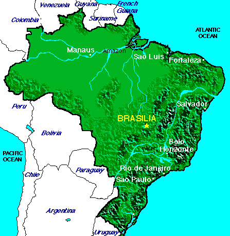 |
| 1. What are Brazil's geographic coordinates? | |
| 2. What is Brazil's area? | |
| 3. Describe Brazil's elevation. | |
| 4. Describe Brazil's terrain? | |
| 5. List the rivers. Where are the rivers located? | |
| 6. Lists the mountains ranges. Where are they located? | |
| 7. List the plateaus. Where are they located? | |
| 8. Name the archipelago. Where is it located? | |
| 9. What is the name of Brazil's rain forest? Where is located? | |
| 10. What countries does Brazil share a common border with? | |
| 11. How is Brazil's land used? |
Students use the web sites below to answer the questions on the T chart.
http://photius.com/wfb2000/countries/brazil/brazil_geography.html
This is a fact sheet about Brazil. The information includes Brazil's geography, location, land boundaries, coastline, terrain, elevation, land use and resources.
http://ecobrazil.com/geo.asp?pg_ifcentral_ID=29
This web site provides geographical information and colorful photos about Brazil's Atlantic Coast, Central Plateau, Amazon Basin
www.studyweb.com/links/2450.html
This site provides extensive information
about Brazil's geography,
government, major cities, economy,
people, regions, history, and culture.
www.brazilinfo.net/sky3/usbrazi2/public_html/brazil-geography.html
Map of Brazil's 5 Regions.
www.nationbynation.com/Brazil/Geo.html
Find out about Brazil's location, geography, and climate.
www.worldrover.com/vital/brazil.html
This site provides information about Brazil's government, history, population, geography and contains maps.
http://agbrazil.com/brazil_s_agriculture_frontier.htm#brazil_s_cerrados_overview and http://agbrazil.com/the_vast_wasteland.htm#the_vast_wastland and
http://agbrazil.com/terrain_and_vegetation.htm#terrain_and_vegetation
The three web sites listed above contain geographic information about Brazil Cerrados or agricultural frontier.
Summary:
Students share their information about Brazil's geography with the class through oral and written reports. Pictures and maps that will be gotten from the above web sites or drawn by the students will be used as visual aids.
Evaluation:
Students will be evaluated on their use of the Internet to find information about Brazil's geography and synthesize that information to produce oral and written reports. Students should also be able to conclude that there is a relationship between the geography of a region and its economy. Students will also be evaluated on their choice and use of visual aids, and their ability to communicate the information in their reports to the class in their presentation.
Follow Up:
Students produce a three dimensional topographic map of Brazil. Papier mache or modeling clay may be used. The map key will include rivers, lakes, mountains, plateaus, and rain forests.
![]() Click
here to return to the Table of Contents.
Click
here to return to the Table of Contents.